Moving Forward from Disaster
Researchers publish a field guide on the physical processes and the social implications of the 2018 Montecito Debris Flows.
Community perceptions of hazard and disaster preparedness have changed in Santa Barbara county following the Montecito debris flows of January 9, 2018. Many residents of Montecito, CA had never heard of the term “debris flow” and could not conceptualize the devastation that would follow. As the community continues to rebuild, it must better implement disaster risk reduction measures. In a recent Geological Society of America publication, researchers including Environmental Studies professors Ed Keller and Summer Gray composed a field guide to assist with these measures.
Several weeks before the debris flows, the Thomas Fire had burned the hill slopes above Montecito. The linkage between the Thomas Fire and debris flows can be explained by a periodic cycle known as the the wildfire-debris flow cycle. "With climate change and human interference with fire processes,” say the researchers, “the fire intensity is apparently increasing, and the fire season is now nearly the entire year.” After a fire, the risk of floods and debris flows increase due to vegetation loss and soil exposure. In the second stage, precipitation, rainfall further increases the risk of debris flow. In Montecito, the debris flow occurred just a few weeks after the fire leaving no time for vegetation recovery. Additionally, within a five-minute period, there was an intense burst of rain, approximately 15mm. In the third process, soil exposure, caused by the fire, increases sediment runoff as well as hill-slope and rill erosion. Extensive rilling contributes to the generation of mud, which coalesces in bolder-rich channels and causes a sediment and fluvial flushing event (or debris flow).
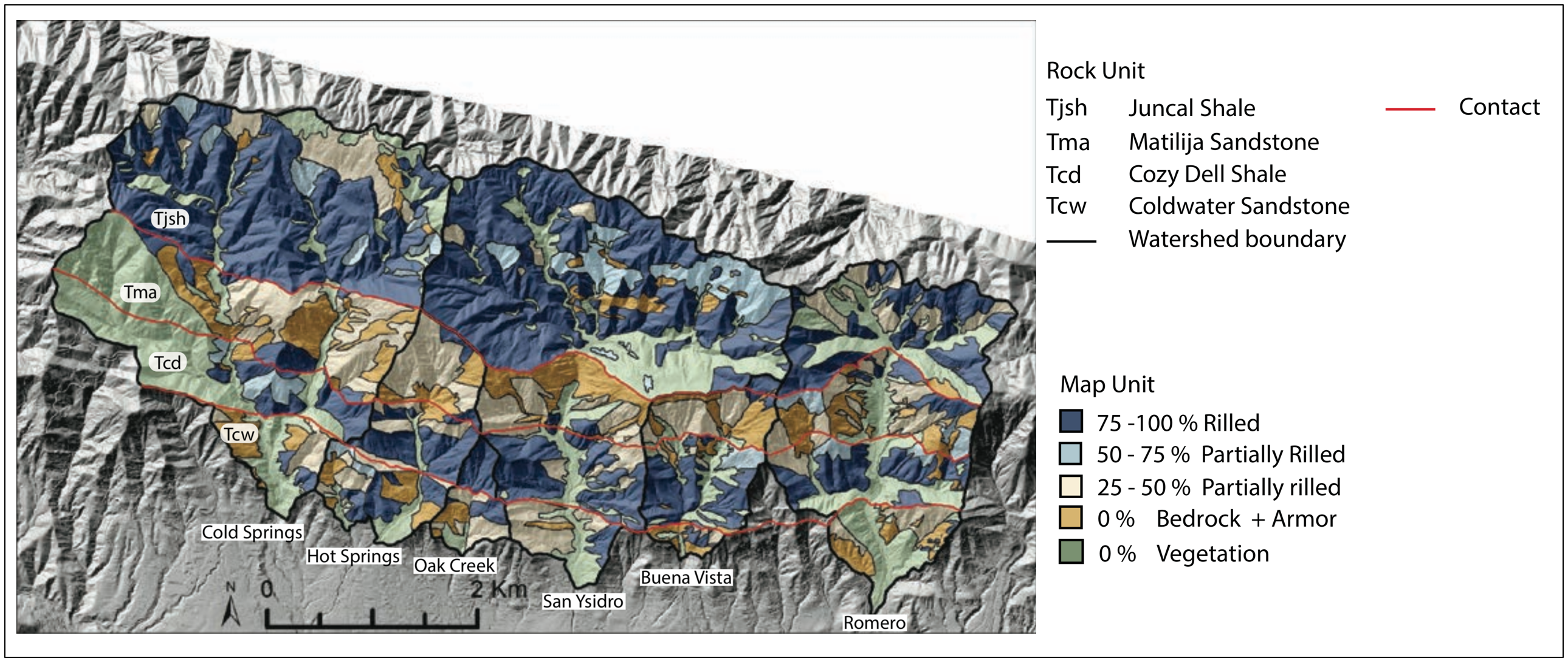
Map of the extent of rill networks in the drainages that produced debris flows. Percentages next to the map unit denote the maximum and minimum area of the hillslope that is rilled as measured on photo orthomosaics.
In Montecito, extensive networks of levee-lined rills were observed in the upper parts of the watersheds and were hypothesized to be the primary mechanism that initiated the flow. The key distinction between these rills and their counterparts is their morphology. While “regular” rills are water-rich and have fluid flow, levee-lined rills have high sediment concentrations and are governed by granular flow. In observing and analyzing the source areas of the 2018 debris flow, the researchers were able to determine that boulder composition and topography were key in calculating the potential for rilling to generate mud for debris flows. The researchers looked at boulder morphology and weathering at four different debris flow deposits between Montecito and Santa Barbara to help map the flow paths of debris from the source area. The researchers also assessed boulder morphology chronology at these stops, which helped them gain an understanding of debris flow history and the implications for defining exposure of debris flow hazard over time and space.
The first site was between the mouth of Montecito Creek and the Biltmore Hotel. At this site, researchers observed the weathering rinds of boulders in the eastern and western channel of the creek. The eastern channel received little flow during the 2018 debris flow while the western channel is where the flow entered the ocean. Stratigraphy of this channel suggests the presence of multiple debris flows at this site through history. In the San Ysidro Creek, the second site and the largest debris flow of the 2018 event, the researchers discuss the source area and physical processes: the debris basin overflowed and caused the flow to widen, which contributed to the damage downstream. In the final two site visits, the Mission Ridge anticline and Mission Creek, the team explored the debris flow chronology in different areas impacted by the debris flow including: Orpet Park (Mission Ridge anticline) and Rocky Nook Park and Mission Park (Mission Creek).
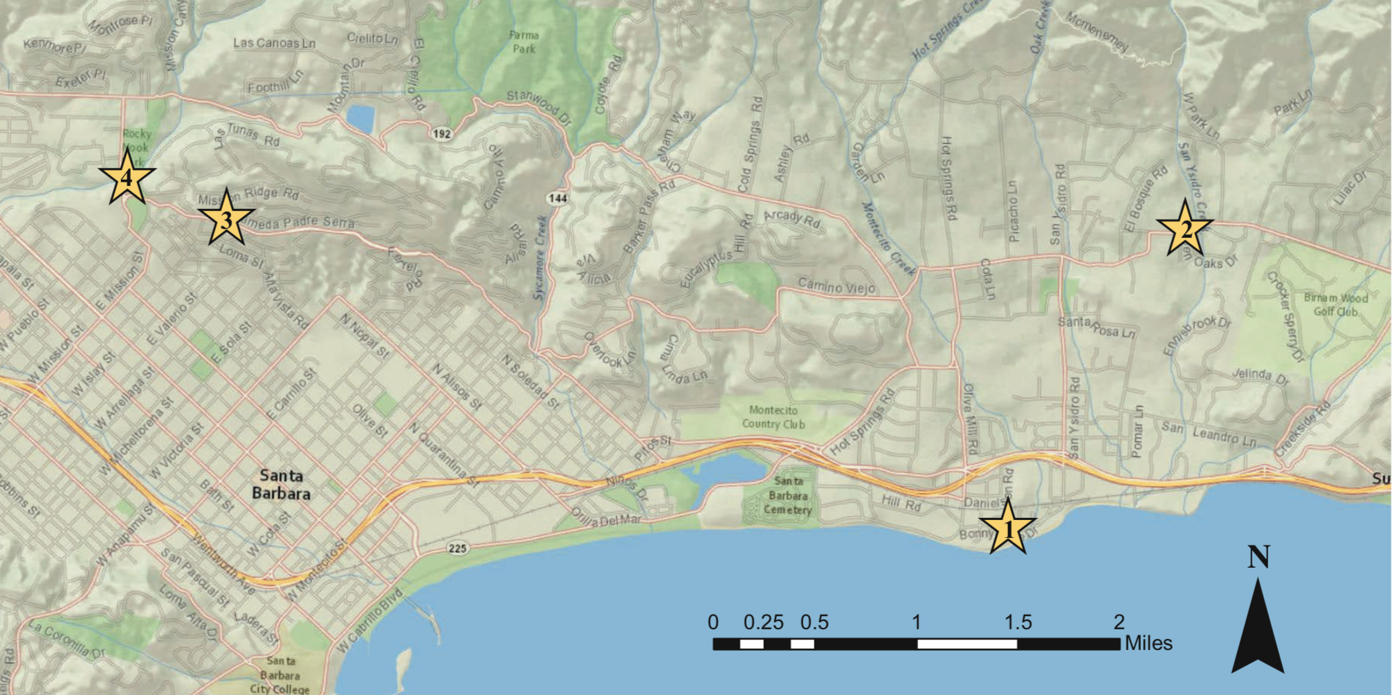
Map of the Santa Barbara–Montecito area showing numbered field-trip stops.
The final section of this guide delves into the social implications surrounding community, disaster preparedness and social vulnerability. Community members of Montecito, CA were unaware of the area's vulnerability to debris flow, and, as mentioned earlier, many residents did not know the terms "debris flow." This is why the events of the 2018 Montecito debris flow raise the importance of disaster risk reduction measures taking into account the particularities of geography and the social implications of vulnerability. According to the guide: "[a]s more people live in hazard-prone areas, debris flows increasingly enter into sociocultural contexts, urban environments, and relationships of privilege and disempowerment." The qualitative assessments of disaster and vulnerability reported in this guide factor in these variables that quantitative methodologies may have otherwise failed to capture.
By interviewing and surveying community members, the team was able to illustrate key themes of social vulnerability of Montecito residents. The first sheds light into an invisible labor force, rejecting the notion of Montecito being made up of only wealthy people. Around one third of the fatalities consisted of working-class immigrant families that make up a portion of the 9% of residents in the community who are non-white. The second theme factors in the temporal dimension of vulnerability where a lack of knowledge of debris flow and the area's history rendered residents vulnerable. The last dimension focuses on the failures of communication from county officials to residents especially in regards to evacuations. Evacuation procedures for the debris flow, conceptually a north-south hazard, mirrored the evacuation lines established for the Thomas Fire, which were east-west. By exploring the local dynamics of the Montecito community and the geographic features that shape both spatial and temporal components of vulnerability, the researchers can help better educate the community, as it rebuilds, about the potential hazard.